Holyhead
Moreton Road
Moreton Road
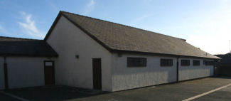
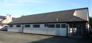
The 1923 OS map of Holyhead shows the drill hall in a quadrangle of land behind Moreton street, Kings Road and Maes Hyfryd. Aerial views show a drill hall in exactly the same spot and of roughly the same shape. These photos are of that building, though if it is the same drill hall as the one in the 1923 map, it has been extensively refinished. We speculated that it may have been constructed or modernised in the same shell or foundations. It has quite a distinctive footprint. We would be grateful for any information on this drill hall.
This drill hall is in use by the 6th Cadet Battalion RWF. The long thin extension to it is a firing range. At the front of the plot of land is a smaller building, which is modern. This one is used by the ATC.
This drill hall is in use by the 6th Cadet Battalion RWF. The long thin extension to it is a firing range. At the front of the plot of land is a smaller building, which is modern. This one is used by the ATC.
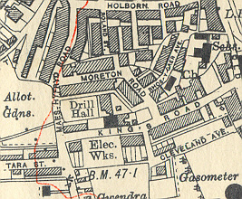
Map from a private collection. We
are grateful for the owners permission to reproduce this extract
© All material is copyright - refer to the
Terms of Use
the first attempt at content
Introduction
About
Anatomy
Drill
 Database
Memorabilia
Resources Glossary
Saving Halls Participate Contact What's New? Terms of Use
Drill
Database
MemorabiliaResources Glossary
Saving Halls Participate Contact What's New? Terms of Use
The Drill Hall Project - Charting a neglected legacy